Top 10 Land Surveying Techniques Every Engineer Should Know
Introduction: Land surveying is an essential discipline for civil engineers, architects, urban planners, and construction professionals alike. It involves the precise measurement and mapping of the Earth’s surface to define boundaries, plan infrastructure, and ensure accurate construction. In this comprehensive guide, we will explore the top 10 land surveying techniques that every engineer should be familiar with. Whether you’re new to the field or looking to deepen your knowledge, understanding these techniques is crucial for success in engineering projects.

- Global Navigation Satellite System (GNSS): GNSS, including GPS (Global Positioning System), GLONASS, and Galileo, revolutionized land surveying by providing accurate positioning data. Engineers use GNSS for precise point positioning, establishing control networks, and conducting topographic surveys. This section will delve into how GNSS works, its applications in surveying, and the importance of differential correction techniques like RTK (Real-Time Kinematic) for achieving centimeter-level accuracy.
- Total Station Surveying: Total stations combine electronic theodolites with distance meters, enabling engineers to measure angles and distances with high accuracy. This technique is essential for boundary surveys, construction layout, and topographic mapping. We’ll explore the components of a total station, its operation principles, and advanced features such as reflectorless measurement and robotic total stations.
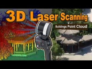
- 3D Laser Scanning:

Source:http://www.youtube.com/@Foxtechhobby Also known as LiDAR (Light Detection and Ranging), 3D laser scanning captures millions of points to create highly detailed digital terrain models (DTMs) and three-dimensional representations of structures. This section will cover the technology behind laser scanning, its applications in as-built surveys, volumetric analysis, and heritage preservation. Case studies showcasing the benefits of LiDAR in complex engineering projects will be highlighted.
- Photogrammetry in land surveying: Photogrammetry uses aerial or terrestrial photographs to create accurate maps and 3D models. Engineers leverage drones and specialized software to stitch together overlapping images and generate detailed orthophotos and point clouds. This part of the article will discuss the workflow of photogrammetry, its advantages in large-scale surveys, and its role in environmental monitoring and disaster management.
- Geographic Information System (GIS): GIS integrates spatial data with attribute information to analyze patterns, make informed decisions, and create interactive maps. Engineers utilize GIS for site selection, infrastructure planning, and spatial analysis. We will explore GIS applications in land management, urban development, and the integration of survey data with other datasets for comprehensive project planning.
- Remote Sensing:

Source:http://www.youtube.com/@geospatialmedia Remote sensing involves gathering information about the Earth’s surface from aircraft or satellites. It provides valuable data for land cover classification, vegetation analysis, and monitoring environmental changes over time. This section will discuss different types of remote sensing techniques, such as multispectral and hyperspectral imaging, and their applications in engineering projects like flood risk assessment and transportation planning.
- Topographic Surveys: Topographic surveys depict the natural and man-made features of a landscape, essential for designing infrastructure and understanding terrain characteristics. Engineers conduct these surveys using various methods, including GNSS, total stations, and LiDAR, to generate contour maps and digital elevation models (DEMs). We will explore the process of conducting topographic surveys, interpreting survey data, and their role in preliminary site assessments.
- Boundary Surveys: Boundary surveys determine property lines and legal boundaries to prevent disputes and ensure accurate land ownership records. Engineers use deed descriptions, historical records, and field measurements to establish property boundaries according to legal standards. This section will discuss the importance of boundary surveys in real estate transactions, land development, and the resolution of property disputes.
- Leveling in land surveying:

Source:http://www.youtube.com/@illinoissurveyor471 Leveling is fundamental for establishing accurate height measurements across a site or along a route. Engineers use digital levels and optical instruments like auto levels to determine elevations and create precise contour maps. This part will cover the principles of leveling, techniques for reducing errors, and its role in ensuring grade accuracy for roads, railways, and pipelines.
- Construction Staking in land surveying: Construction staking involves marking the positions and levels of structures and infrastructure elements according to design plans. Engineers use survey data to set out reference points, alignments, and elevations on-site, ensuring that construction proceeds accurately and within specified tolerances. We’ll explore the role of construction staking in earthworks, building layout, and infrastructure projects, emphasizing its importance in project execution and quality control.
Conclusion: Mastering these top 10 land surveying techniques is indispensable for engineers involved in infrastructure development, urban planning, and environmental management. By understanding the principles and applications of GNSS, total station surveying, 3D laser scanning, and other advanced techniques, engineers can enhance project efficiency, accuracy, and sustainability. As technology continues to evolve, staying updated with emerging surveying tools and methodologies will be crucial for maintaining a competitive edge in the engineering industry.
In summary, this guide has provided a comprehensive overview of the essential land surveying techniques that every engineer should know. Whether you’re conducting a boundary survey, planning a construction project, or analyzing environmental data, these techniques form the foundation for precise and informed decision-making in engineering practice. By harnessing the power of GNSS, LiDAR, photogrammetry, and other surveying technologies, engineers can navigate the complexities of modern infrastructure projects with confidence and precision.
If you want to get more knowledge about this so read more.
If you want more articles about Civil Engineering click on link.


